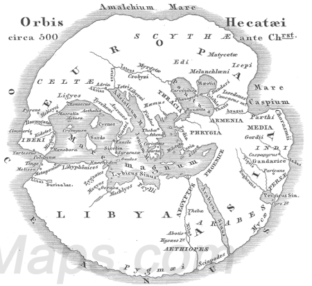
The first Greek geographical work, written in prose around 500 B.C., was Hecatæus’ Periegesis [‘Guide Round’] or Periodos Ges [‘Journey Round the World’ or ‘General Survey of the inhabited world as known at that time’]. A great part of it was taken up with an account of places and districts bordering on the sea, and it must have borne a considerable resemblance to what was afterwards called a Periplus, or Coasting Survey. It has only been preserved in some 300 fragments, and the majority of these are of the briefest description, having been preserved in the epitome of the work of Stephanus of Byzantium, which gives little more than the names of places with the countries to which they belonged. However, it does appears that, in part of his written work at least, Hecatæus was far from confining himself to a dry geographical description of the country, but discussed at considerable length upon its natural curiosities, and the manners and customs of the local inhabitants. He, however, certainly added a number of mere geographical details, such as are not found in Herodotus’ Histories, as we find the names of not less than fifteen cities of Egypt cited from him by Stephanus. When we are told that he enormously improved Aristagoras’ map, this probably means that he criticized it in his text rather than re-drew the map.
The Periegesis was divided into two books, ‘Europe’ and ‘Asia’ the latter also including Libya [Africa]. Hecatæus had travelled in Asia and Egypt, and is said to have made a map, well spoken of by Agathemenus, and probably based upon an “improved” reproduction of the Anaximander map. Modern reconstructions reasonably show this map, which is likely to have accompanied his book, as circular, with the ocean surrounding a landmass which ends eastwards at the Indus River and the Caspian “Gulf”. Hecatæus believed that the upper surface of the earth pillar was a curving disc. The Mediterranean Sea was the center of the “world island” composed of lands bordering this sea, the whole being surrounded by a circumfluent ocean-stream. The circular shape of flat maps in the early period was laughed at by later Greeks. Hecatæus is the first writer we know of to think of the Caspian as flowing into the ocean, an idea which long persisted. On the Black Sea, an area colonized by Miletus, he was clearly informative, and his writing may have helped Herodotus on areas like Thrace. To the north of the Danube, according to Hecatæus, were the Rhipæan [gusty] Mountains, beyond which were the Hypernotians [men of the far south]. Ancient and modern opinion has differed on the location of the Rhipæan Mountains; Aeschylus and Pindar imagined that they were at the source of the Danube. In west Africa Hecatæus clearly knew some places on the coast of Morocco. His view of the Nile seems to have been that it came, somehow, from the southern ocean.
In Book Two, comprising the coast of Libya [Africa], from the confines of Egypt to the Pillars of Hercules [Straits of Gibraltar], one finds a mere Periplus, or coast-description. noticing many ports and small islands; while the only tribes of the interior he is known to have mentioned are the Mazyes and Zygantes – obviously the same with the Maxyes and Gyzantes of Herodotus, both of which lived within a short distance of the sea, near the Tritonian Lake. The most distant places that he enumerates towards the west are Metagonium, a name which we find in later times applied to a promontory and people not far from the Pillars of Hercules; and Thinga, evidently the same place that was subsequently called Tinga, or Tingis [the modern Tangier], just without the Straits. It is probable also that his river Liza was the same as the Lixus of later geographers, on the Atlantic coast of Mauritania, but this is far from certain.


